
Featured Research
LHI actively develops research ideas that are beneficial to both the academia and the industry. The in-house research work refines LHI’s knowledgebase that eventually enhance the quality of work being presented to the clients. Some of noteworthy recent contribution of LHI researchers are as follows.
Application of Hydrological Study Methodologies Used in African Context for Water Security in Asian Countries
Principle Investigator : Dr. D.P.C. Laknath
Published as a Book Chapter of Springer Water. Springer, Switzerland
Climate change has threatened the water resources of the African and Asian continents, emphasising the importance of climate resilient water resources management. In this context, hydrological studies are prerequisite components of water resource management plans, including water conservation and mitigation of disasters related risks due to floods and drought. However, factors such as (i) data inadequacy and (ii) unaffordable costs of the already accepted methodologies are major constraints inherent in hydrological studies of developing countries.
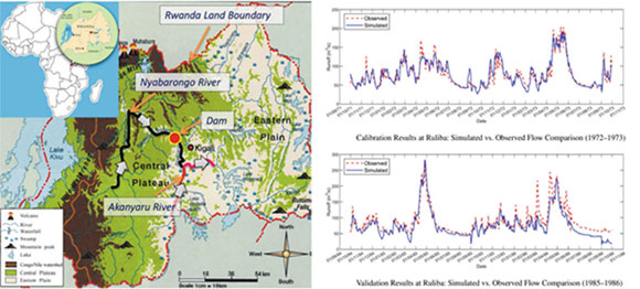
The main objective of this study is to address these two constraints related to the African country and to propose similar solutions for Asian countries, which are being experienced similar constraints. A hydrological study was carried out for the tributaries of the Nile River (Nyabarongo—Akanyaru) in Rwanda, focusing on a potential dam site. As incompleteness of recorded rainfall and discharge data is a major issue identified during the analysis, suitable scientific and systematic measures have been taken. For the selected minimum of 30 years of analysis period, flow characteristics were simulated by 3 methods: (i) Specific Discharge Method (SDM), (ii) MIKE 11 NAM, and (iii) HEC—HMS simulations. From our analysis, it has been identified that all 3 methods have given approximately similar results with the same accuracy level. However, compared to NAM and HEC-HMS, SDM was recognized as easy handling, fast and cost-effective method. Thus, as an outcome of this research, (i) suitable adjustments for incomplete data and (ii) cost effective, fast and easy handing methodology for flow characteristic simulations were introduced for Asian countries which are being constrained with the similar barrier.
Laknath D.P.C., Sirisena T.A.J.G. (2021) Application of Hydrological Study Methodologies Used in African Context for Water Security in Asian Countries. In: Babel M., Haarstrick A., Ribbe L., Shinde V.R., Dichtl N. (eds) Water Security in Asia. Springer Water. Springer, Cham.
https://link.springer.com/chapter/10.1007/978-3-319-54612-4_14Effectiveness of Dummy Water Levels in Physical Models to Optimize the Toe and the Crest Levels
Principle Investigator : Dr. D.P.L. Ranasinghe
Published in Proceedings of the 8th International Conference on the Application of Physical Modelling in Coastal and Port Engineering and Science (Coastlab2020)
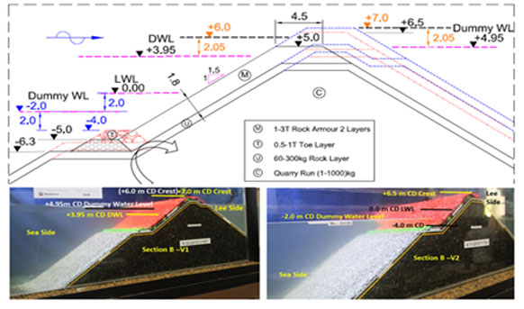
Physical models can save a substantial amount from the actual construction coat even though the procedure is cost and time consuming than the other design techniques. The objective of this study was to use the constructed physical model to represent the different toe and the crest levels by adjusting the water levels during the model testing. Application of dummy water levels for toe optimization has been adopted for the various 2D models done in Lanka Hydraulic institute Ltd (LHI) and the outcome of two of them are (shallow and deep water coastal structures) presented in this paper. The crest optimization has been done for a deep breakwater by changing the water levels to represent the effective freeboard for the overtopping. The same design waves were applied for different water levels as deep water wave conditions are not much varying at the adjacent water depths. Since the toe stability is assessed by considering maximum wave height that can be generated at the critical low water level, effective water depth at the toe has been considered while optimizing the toe elevation using adjusted water levels. This paper includes the discussion on toe stability for deep and shallow water sections as well as the suitability of dummy water levels for engineering judgments while optimizing the crest and toe levels of the coastal structures. The results concluded that the dummy water levels can be used as an alternative method for crest and toe level optimization instead of having structural modifications of the model.
Ranasinghe, D.P.L., Kumara, I.G.I.K., Engiliyage, N.L., Raveenthiran, K. (2020). Effectiveness of Dummy Water Levels in Physical Models to Optimize the Toe and the Crest Levels. Proceedings of the 8th International Conference on the Application of Physical Modelling in Coastal and Port Engineering and Science (CoastLab20) in Zhoushan, China.
https://www.iahr.org/library/infor?pid=8784Preliminary Assessment of Wave Energy in Sri Lanka
Principle Investigator : Dr. Kusalika Ariyarathne
Published in Proceedings of virtual Conference on Coastal Engineering, 2020
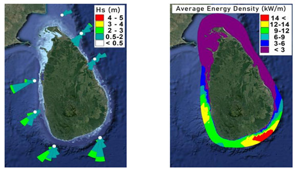
Preliminary results of a numerical model developed to detail spatial and temporal assessment of theoretically available near shore wave energy, and potential wave energy extracting sites, along the Sri Lankan coast is presented in this paper. Wave energy is estimated applying Danish Hydraulic Institute’s Mike 21 Spectral Wave (SW) module. The model is developed and applied covering an area along the coast line of entire country extending from 315000 to 640000 mE, and 602000 to 1164000 mN. Model was run with boundary inputs of wind and wave, based on long term measured, and long term hindcast directional wave data available at seven locations, which are well distributed around the country. Model calibration and validation are carried out based on long term measured directional wave data at Colombo, Sri Lanka. Based on the estimated wave energy density maps, and spatial and temporal energy variations, Hambantota, in South East coast is identified as the most feasible location for wave energy harnessing. Annual and seasonal availability of the wave energy, for Hambantota area, at 25 m depth, were looked into in detail. In the above area, mean annual energy potential was estimated as 10 kW/m at 25 m depth, whereas maximum annual potential energy was estimated as 36 kW/m. During South West monsoon, where high waves are present, the mean energy potential is estimated as 15 kW/m
Ariyarathne, K., & Jayarathne, P. (2020). Preliminary Assessment of Wave Energy in Sri Lanka. Coastal Engineering Proceedings, (36v), papers.21.
https://doi.org/10.9753/icce.v36v.papers.21Simulation of 2004 Tsunami Inundation in Galle City in Sri Lanka and Revisit the Present Evacuation Measures
Principle Investigator : Dr. D.P.C. Laknath
Published in Proceedings of virtual Conference on Coastal Engineering, 2020
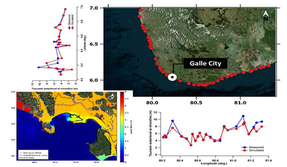
Tsunami inundation was successfully reproduced for the Galle City, Sri Lanka using Delft3D-Flow model and Delft Dashboard Tsunami Tool. Previously identified tsunami hazard maps agreed with the simulation results. Existing tsunami early warning system and preparedness for evacuation are in a favourable condition. Based on the outcome of numerical simulation and field investigations, suitable horizontal evacuation measures were proposed, and vertical evacuation points were suggested primarily considering the identified hazardous zones with lack of proposed buildings and evacuation routes in previous studies
Laknath, D., Josiah, N., Sewwandi, K., & Araki, S. (2020). Simulation of 2004 Tsunami Inundation in Galle City in Sri Lanka and Revisit the Present Evacuation Measures. Coastal Engineering Proceedings, (36v), papers.36.
https://doi.org/10.9753/icce.v36v.papers.36Analysis of Cyclone Events in Bay of Bengal and Simulation of Storm Surge in Eastern Coast of Sri Lanka
Principle Investigator : Dr. D.P.C. Laknath
Awarded as the “Excellent Paper Award” at The International Conference on Asian and Pacific Coasts (APAC) 2019, held in Hanoi, Vietnam and published in Proceedings of the 10th International Conference on Asian and Pacific Coasts (Springer publication)
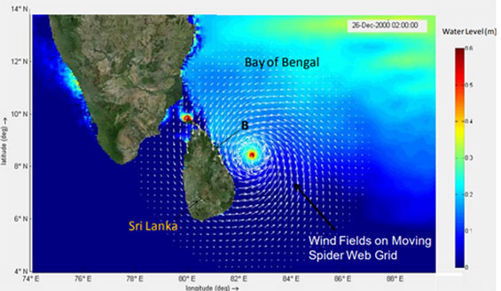
Characteristics and behavior of cyclones occurred in Bay of Bengal during last 4 decades in the light of global warming effect and applicability of Delft3D modeling system with Delft Dashboard Tropical Cyclone Tool to simulate storm surge levels in eastern coast of Sri Lanka during the passage of 2000 Cyclone (BOB 06) were investigated in this research. Through the statistical analysis of cyclone characteristics, increasing trend of sustained wind speed with the increase of sea surface temperature (SST) over the Bay of Bengal was identified for the considered period though there is no trend for annual cyclone variation. In this study, spatially varying wind and pressure fields of 2000 Cyclone were reproduced by using Delft Dashboard Tropical Cyclone Tool. FLOW model of Delft3D system was used to simulate the hydrodynamic effects caused by wind, atmospheric pressure changes and tidal forces. Thus, Delft Dashboard Tropical Cyclone Tool, together with Delft3D FLOW-WAVE coupled modeling system could simulate storm surge level in eastern coast of Sri Lanka for 2000 Cyclone event with a satisfactory level of accuracy.
Laknath D.P.C., Sewwandi K.A.H.S., Hailong H. (2020) Analysis of Cyclone Events in Bay of Bengal and Simulation of Storm Surge in Eastern Coast of Sri Lanka. In: Trung Viet N., Xiping D., Thanh Tung T. (eds) APAC 2019. APAC 2019. Springer, Singapore.
https://doi.org/10.1007/978-981-15-0291-0_179Adaptation of Directional Wave Measurement in 3D Physical Model to Eliminate the Reflection Component in Uni-Directional Waves
Principle Investigator : Dr. D.P.L. Ranasinghe
Published in Proceedings of 28th International Offshore and Polar Engineers (ISOPE), 2018
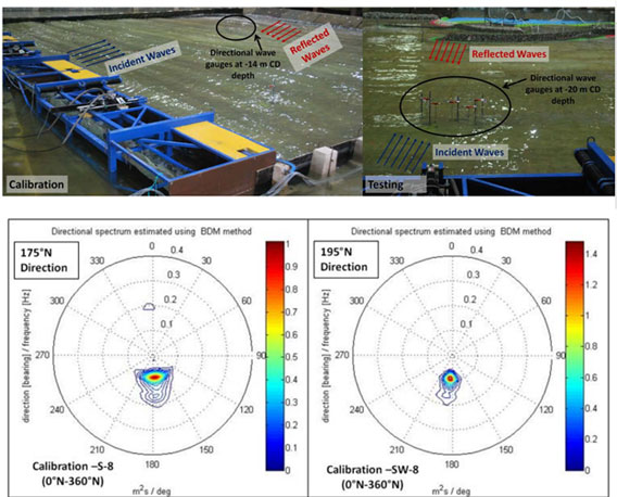
Directional wave gauges are used to estimate the directional spreading of the generated wave energy spectrum in 3D basin despite the high cost involved in. In this study, five non-directional wave gauges array has been used to capture the directional distribution at desired locations to omit the reflection component in uni-directional waves (175°N and 195°N). The directional wave measurements have been carried out at the nearshore during the calibration to assess wave reflection from the boundaries if any. During the testing, directional gauge system was placed at the offshore to assess the incident wave climate. The spectral analysis has been performed to identify the incident wave component by selecting a narrow direction band of 120°N -240°N out of the entire direction band of 0°N-360°N. The results depicted that 3% of the observed wave heights at -20 m depth contains the reflected waves from the breakwater structure at -14 m depth. Further, this method has been successfully used to generate the required